 Syken metatietopalvelu
Manner-Euroopan järvijääpeite (VIIRS) 2024– / Lake Ice Extent for the Continental Europe (VIIRS) 2024–
[FI]
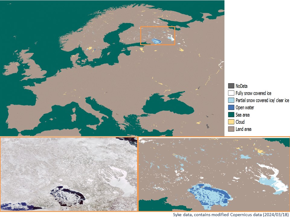
Tämä aineisto tarjoaa tietoa Manner-Euroopan järvijääpeitteestä (Lake Ice Extent, LIE), jota seurataan optisilla aallonpituuksilla tehtyjen satelliittihavaintojen avulla. Aineisto kattaa ajanjakson vuodesta 2024 lähtien ja sen tuottajina ovat Suomen ympäristökeskus (Syke), Ilmatieteen laitos (IL) ja ENVEO IT GmbH. Aineisto on päivitetty versio Pohjois-Euroopan järvijäätuottesta (LIE-NE), jota on tuotettu vuosille 2017-2024. Aineistotuotanto on osa Copernicuksen maakartoituspalvelua (Copernicus Land Monitoring Service), ja sitä rahoittaa Euroopan Unioni. Aineisto kuuluu Syken avoimiin aineistoihin (CC BY 4.0).
Havainnot ovat peräisin NOAA-20 (JPSS-1) VIIRS (Visible Infrared Imaging Radiometer Suite) 375 metrin satelliittikuvista, jotka tarjoavat jatkuvaa järvijääpeiteseurantaa ympäri vuoden lukuun ottamatta hämäriä tai pimeitä olosuhteita kaamoksen aikana. Aineiston resoluutio on 0,0025 astetta (WGS84). Lähinfrapuna- ja lämpökanavia käytetään järvijääpeitteen tulkintaan ja luokitteluun, mikä vähentää kesäisiä virhetulkinnan lähteitä kuten leväkukintojen vaikutuksia.
Aineisto tarjoaa luokituksen järvien jääpeittoalasta, sisältäen luokat 1) täysin lumipeitteinen jää, 2) osittain lumipeitteinen jää/kirkas jää ja 3) avovesi. Luokittelu on saatavilla pilvettömille pikseleille, ja pilvipikselit on merkitty erillisillä arvoilla. Verrattuna järvijääaineiston aiempaan versioon (MODIS, 2017–2024), VIIRS-aineisto tarjoaa edistyneemmän pilvialgoritmin pilvien seulontaan ja kykenee tunnistamaan mm. ohuet pilvet kylmän veden yllä. Käyttäjän on hyvä huomioida, että jäätymisen ja jäänlähdön aikana menetelmä ei aina kykene erottamaan, onko kyse tumman (ohuen, puoliläpäisevän) jään päällä olevasta vedestä vai avovedestä. Tällaisissa tilanteissa jääpeite on usein kuitenkin jo tummaa, pirstoutunut ja/tai rakenteeltaan heikko, eikä täten aiheuta kaikissa käyttötapauksissa merkittävää haittaa loppukäyttäjälle.
Alkuperäisen datan lähdeviitteet: Cao ym. 2012, NOAA JPSS Visible Infrared Imaging Radiometer Suite (VIIRS) Sensor Data Record (SDR) from IDPS. NOAA National Centers for Environmental Information. doi:10.7289/V58G8HSZ.
[EN]
This dataset provides daily Lake Ice Extent (LIE) information for Continental Europe, monitored using optical satellite remote sensing. The dataset covers the period since 2024 and is generated by the Finnish Environment Institute (Syke), Finnish Meteorological Institute (FMI) and ENVEO IT GmbH, commissioned by Copernicus Land Monitoring Service with funding by the European Union. The dataset is an upgraded version of the Northern Europe Lake Ice Extent product (LIE-NE), which has been produced since 2017 until 2024. The dataset follows Syke's open data policy (CC BY 4.0).
Information is sourced from NOAA-20 (JPSS-1) VIIRS (Visible Infrared Imaging Radiometer Suite) 375 m satellite images, offering a continuous monitoring of lake ice throughout the year excepting for low-light conditions during the polar night. The dataset resolution is 0.0025 degrees (WGS84). Near-infrared and thermal bands are utilized to interpret and classify lake ice extent, minimizing misinterpretations during the summer, such as those caused by algae blooms.
The dataset provides classifications for lake ice extent, including the classes (1) Fully snow-covered ice, (2) Partially snow-covered ice/clear ice, and (3) Open water. Classification is available for cloud-free pixels, and cloud pixels are marked with distinct values. Compared to the previous version of the Lake Ice Extent dataset (MODIS, 2017–2024), the VIIRS dataset offers a more advanced cloud algorithm to enhance cloud screening, and is able to identify, among others, thin clouds over cold water. The user should be aware that during the freezing and break-up of ice the method cannot always detect whether the target represents water on dark (thin, semitransparent) ice or open water. However, in these cases the lake ice is already fragmented and/or dark and weak and thus does not always cause disadvantage for the end users depending on the user case.
Original data reference: Cao et al. 2012, NOAA JPSS Visible Infrared Imaging Radiometer Suite (VIIRS) Sensor Data Record (SDR) from IDPS. NOAA National Centers for Environmental Information. doi:10.7289/V58G8HSZ.
Versiointi:
Aineisto on versioitu, ja viimeisin tuoteversio on 2.2.1 (voimassa alkaen 19. huhtikuuta 2024).
Simple
Identification info
- Title
-
Manner-Euroopan järvijääpeite (VIIRS) 2024– / Lake Ice Extent for the Continental Europe (VIIRS) 2024–
- Date (Publication)
- 2024-07-01
- Point of contact
-
Organisation name Electronic mail address Role Suomen ympäristökeskus
Point of contact
-
SYKE resource classification
-
-
Satelliittihavaintotieto
-
- Keywords
-
-
Ei-Inspire
-
TARKKA
-
jääpeite
-
järvet
-
lake ice
-
Copernicus
-
Resource constraints
- Use constraints
- Other restrictions
- Other constraints
-
Creative Commons Nimeä 4.0 Kansainvälinen
[FI] Aineisto noudattaa [Copernicuksen maakartoituspalvelun käyttöehtoja]( https://land.copernicus.eu/terms-of-use) seuraavien ehtojen mukaisesti:
<käyttöehdot>
1. Nimeäminen: jakaessaan tai välittäessään Copernicuksen maakartoituspalvelun tuotteita ja palveluita (mukaan lukien havainnot, ohjelmistoskriptit, verkkopalvelut, käyttö- ja metodologiset ohjeistukset ja vastaavat) yleisölle käyttäjien on ilmoitettava yleisölle näiden tuotteiden ja palveluiden lähde. Käyttäjien on mainittava, että Copernicuksen maakartoituspalvelun tuotteet ja palvelut on tuotettu "Euroopan unionin rahoituksella".
2. Sovittaminen ja datan muokkaus: Jos käyttäjät sovittavat tai muokkaavat Copernicuksen maakartoituspalvelun tuotteita ja -palveluita, heidän on ilmoitettava selvästi, että he ovat tehneet niin.
3. Tekijänoikeudet: Käyttäjillä on kaikki tekijänoikeudet niihin tuotteisiin, jotka he luovat perustuen Copernicuksen maakartoituspalvelun tuotteisiin ja -palveluihin.
4. Ei virallista hyväksyntää: Käyttäjiä kielletään antamasta yleisölle vaikutelmaa siitä, että heidän toimintansa on Euroopan Unionin virallisesti hyväksymää.
[EN] The dataset follows [the terms of use of Copernicus Land Monitoring Service]( https://land.copernicus.eu/terms-of-use) under the following conditions:
1. Attribution: When distributing or communicating Copernicus Land Monitoring Service products and services (including data, software scripts, web services, user and methodological documentation, and similar) to the public, users are required to inform the public of the source of these products and services. Users must acknowledge that the Copernicus Land Monitoring Service products and services were produced "with funding by the European Union."
2. Adaptation and Modification: If users adapt or modify the Copernicus Land Monitoring Service products and services, they must clearly state that they have done so.
3. Intellectual Property Rights: Users possess all intellectual property rights for the products they create based on the Copernicus Land Monitoring Service products and services.
4. No Official Endorsement: Users are prohibited from conveying the impression to the public that their activities are officially endorsed by the European Union.
- Access constraints
- Other restrictions
- Other constraints
- no limitations
- Spatial representation type
- Grid
- Metadata language
- English
- Topic category
-
- Inland waters
Temporal extent
Spatial extent information
))
- Unique resource identifier
- EPSG:4326
- Codespace
-
EPSG
- Distribution format
-
- GeoTiff ( -)
Digital transfer options
- OnLine resource
- Hierarchy level
- Series
- Statement
-
Aineistoa on tuotettu vuodesta 2024 alkaen Tarkka-palveluun. Aineisto on versioitu, ja viimeisin tuoteversio on 2.2.1 (voimassa alkaen 19. huhtikuuta 2024).
Metadata
- File identifier
- {BECAA0F0-9A28-4AA6-8D28-AC7B7A168296} XML
- Metadata language
- English
- Character set
- UTF8
- Hierarchy level
- Series
- Date stamp
- 2026-04-16
- Metadata standard name
-
ISO19115
- Metadata standard version
-
2003/Cor.1:2006
- Metadata author
-
Organisation name Electronic mail address Role Suomen ympäristökeskus
Point of contact
)))
